
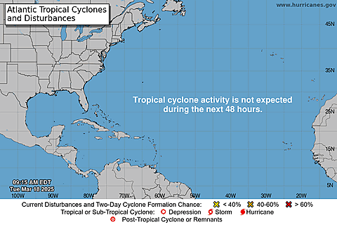
ATLANTIC TROPICAL SNAPSHOT
CLICK LINKS ABOVE TO DISPLAY IMAGES


FUTURE ATLANTIC ACTIVITY (NHC)
CLICK LINKS ABOVE TO DISPLAY IMAGES


NHC TEXT PRODUCTS
CLICK LINKS ABOVE TO DISPLAY TEXT PRODUCTS
715
ABNT20 KNHC 270504
TWOAT
Tropical Weather Outlook
NWS National Hurricane Center Miami FL
200 AM EDT Sat Jul 27 2024
For the North Atlantic...Caribbean Sea and the Gulf of Mexico:
Near the Lesser and Greater Antilles:
An area of disturbed weather over the central tropical Atlantic
Ocean is expected to interact with an approaching tropical wave
during the next several days. Some development of this system is
possible while it approaches the Lesser Antilles during the early
to middle part of next week and moves generally west-northwestward
near the Greater Antilles towards the latter part of next week.
* Formation chance through 48 hours...low...near 0 percent.
* Formation chance through 7 days...low...20 percent.
$$
Forecaster Reinhart
000
ACCA62 TJSJ 302314
TWOSPN
Perspectiva sobre las Condiciones del Tiempo en el Trópico
Centro Nacional de Huracanes del SNM Miami FL
Traducción por el SNM San Juan PR
700 PM EST jueves 30 de noviembre de 2023
Para el Atlántico Norte...Mar Caribe y Golfo de México:
No se espera formación de ciclón tropical durante los próximos 7
dÃas.
Esta es la última Perspectiva sobre las Condiciones del Tiempo en el
Trópico programada regularmente de la Temporada de Huracanes del
Atlántico de 2023. La emisión de rutina de la Perspectiva sobre las
Condiciones del Tiempo en el Trópico se reanudará el 15 de mayo de
2024. Fuera de la temporada, las Perspectivas sobre las Condiciones
del Tiempo en el Trópico serán emitidas según las condiciones lo
ameriten.
$$
Pronosticador Cangialosi
Traductor Colon-Pagan (NWS/WFO San Juan)
000
AXNT20 KNHC 270447
TWDAT
Tropical Weather Discussion
NWS National Hurricane Center Miami FL
0605 UTC Sat Jul 27 2024
Tropical Weather Discussion for North America, Central America
Gulf of Mexico, Caribbean Sea, northern sections of South
America, and Atlantic Ocean to the African coast from the
Equator to 31N. The following information is based on satellite
imagery, weather observations, radar and meteorological analysis.
Based on 0000 UTC surface analysis and satellite imagery through
0415 UTC.
...TROPICAL WAVES...
An eastern Atlantic tropical wave has its axis along 25W, south
of 22N, moving westward at 15-20 kt. Scattered moderate convection
is observed from 08N to 14N and between 24W and 30W.
Another eastern Atlantic tropical wave has its axis along 37W, south
of 22N, moving westward at 10 kt. Scattered moderate convection
is observed from 07N to 13N and between 30W and 38W.
A western Caribbean tropical wave has its axis along 80W, south
of 19N, moving westward at 20-25 kt. A few showers are evident
near the trough axis.
...MONSOON TROUGH/ITCZ...
The monsoon trough enters the Atlantic through the coast of
Mauritania near 20N16W and continues southwestward to 11N35W and
to 07N53W. Scattered moderate convection is present from 07N to
11N and between 39W and 49W.
GULF OF MEXICO...
A weak surface trough in the western Gulf and divergence aloft
continues to generate a few showers and isolated thunderstorms in
the vicinity of the trough and the northern Gulf waters. The Gulf
of Mexico is under the influence of a broad subtropical ridge over
the central Atlantic that extends westward into the basin. Moderate
to locally fresh NE-E winds are found off northern and western
Yucatan. Seas in these waters are 2-3 ft. Elsewhere, light to
gentle winds and slight seas are prevalent.
For the forecast, a ridge will remain in place across the Gulf waters
through Wed allowing for gentle to moderate winds and slight to
moderate seas. Winds will freshen up at night off NW Yucatan over
the next several days. A weak high pressure cell will develop
over the eastern Gulf by Sun.
CARIBBEAN SEA...
A broad upper level trough centered near the central Bahamas
induces scattered showers in the north-central Caribbean,
also affecting Jamaica and Hispaniola. A recent scatterometer
satellite pass indicate that winds to near gale-force are
occurring in association with the strongest convection. The basin
is dominated by a broad subtropical ridge positioned north of the
islands. This ridge forces fresh to strong easterly trade winds
over much of the central and SW Caribbean. Seas in these waters
are 6-8 ft. Moderate to locally fresh easterly breezes and seas of
4-7 ft are found in the eastern Caribbean, Gulf of Honduras and
lee of Cuba. Light to gentle winds and slight to moderate seas
prevail elsewhere.
For the forecast, a tropical wave will move across the western
Caribbean on Sat, reaching the Yucatan Peninsula on Sun. The
Atlantic ridge will build over the east and central Caribbean in
the wake of the wave. This pattern will support fresh to strong
trade winds and rough seas across the central Caribbean into the
middle of next week. Expect moderate to fresh E to SE winds and
building seas over the northwest Caribbean behind the wave axis
through Sun with locally strong winds and rough seas across the
Gulf of Honduras Sun night.
Looking ahead, an area of disturbed weather over the central
tropical Atlantic Ocean is expected to interact with an
approaching tropical wave during the next several days. Some
development of this system will be possible while it approaches
the Lesser Antilles during the early to middle part of next week
and moves generally west-northwestward near the Greater Antilles
toward the latter part of the week.
ATLANTIC OCEAN...
A broad upper level low near the central Bahamas continues to
produce isolated showers over much of the SW North Atlantic,
especially west of 70W. The tropical Atlantic is under the
influence of an expansive subtropical ridge positioned over the
central Atlantic. Fresh easterly winds are found off northern
Hispaniola, along with seas of 4-6 ft. In the far northeast
Atlantic, fresh to locally strong northerly winds are occurring
north of 25N and east of 20W, with the strongest winds affecting
the water passages of the Canary Islands. Seas in these waters are
5-8 ft. Elsewhere, moderate or weaker winds and slight to moderate
seas are prevalent.
For the forecast west of 55W, the Bermuda-Azores high will
dominate the Atlantic forecast waters through the next several
days. It will shift eastward ahead of a weak cold front moving off
the Carolina coast on Sat. The front will stall then dissipate
between northeast Florida and Bermuda Sun into MOn. The pattern
will support fresh to strong E winds off Hispaniola through Sun,
and gentle to moderate breezes elsewhere into Tue. Looking ahead,
winds and seas may increase northeast of the Leeward Islands by
late Tue associated with an approaching tropical wave.
Looking ahead, an area of disturbed weather over the central
tropical Atlantic Ocean is expected to interact with an
approaching tropical wave during the next several days. Some
development of this system will be possible while it approaches
the Lesser Antilles during the early to middle part of next week
and moves generally west-northwestward near the Greater Antilles
toward the latter part of the week.
$$
Delgado
NHC MARINE FORECASTS
CLICK LINKS ABOVE TO DISPLAY TEXT PRODUCTS
000
FZNT23 KNHC 270322
OFFNT3
Offshore Waters Forecast for the Caribbean Sea and Tropical
N Atlantic
NWS National Hurricane Center Miami, FL
1122 PM EDT Fri Jul 26 2024
Offshore Waters Forecast for Caribbean Sea, and the Tropical N
Atlantic from 07N to 19N W of 55W.
Seas given as significant wave height, which is the average
height of the highest 1/3 of the waves. Individual waves may be
more than twice the significant wave height.
AMZ001-271530-
Synopsis for Caribbean Sea, and Tropical N Atlantic from 07N to
19N W of 55W
1122 PM EDT Fri Jul 26 2024
.SYNOPSIS...A tropical wave will move across the western
Caribbean on Sat, reaching the Yucatan Peninsula Sat night into
Sun. The Atlantic ridge will build over the east and central
Caribbean in the wake of the wave. This pattern will support fresh
to strong trade winds and rough seas across the central Caribbean
into the middle of next week. Expect moderate to fresh E to SE
winds and building seas over the northwest Caribbean behind the
wave axis through Sun with locally strong winds and rough seas
across the Gulf of Honduras Sun night.
$$
AMZ040-271530-
Caribbean N of 18N W of 85W including Yucatan Basin-
1122 PM EDT Fri Jul 26 2024
.OVERNIGHT...E to SE winds 10 to 15 kt. Seas 3 to 5 ft.
.SAT...E winds 15 kt S of 20N, and E to SE 10 to 15 kt N of 20N.
Seas 3 to 5 ft.
.SAT NIGHT...E winds 15 to 20 kt S of 20N, and E to SE 10 to
15 kt N of 20N. Seas 4 to 6 ft.
.SUN...E to SE winds 15 to 20 kt S of 20N, and E to SE 10 to
15 kt N of 20N. Seas 4 to 6 ft.
.SUN NIGHT...E to SE winds 15 to 20 kt S of 20N, and E 10 to
15 kt N of 20N. Seas 5 to 7 ft in E to SE swell.
.MON...E winds 10 to 15 kt. Seas 4 to 6 ft.
.MON NIGHT...NE to E winds 10 to 15 kt. Seas 3 to 5 ft.
.TUE...E winds 10 to 15 kt. Seas 2 to 4 ft.
.TUE NIGHT...E winds 10 to 15 kt. Seas 2 to 4 ft.
.WED...E winds 10 to 15 kt. Seas 2 to 4 ft.
.WED NIGHT...E winds 10 to 15 kt. Seas 2 to 4 ft.
$$
AMZ041-271530-
Caribbean N of 20N E of 85W-
1122 PM EDT Fri Jul 26 2024
.OVERNIGHT...E winds 10 to 15 kt. Seas 2 to 4 ft.
.SAT...E winds 10 to 15 kt. Seas 3 to 5 ft.
.SAT NIGHT...E winds 10 to 15 kt. Seas 3 to 5 ft.
.SUN...E winds 10 to 15 kt. Seas 3 to 5 ft.
.SUN NIGHT...NE to E winds 10 to 15 kt. Seas 4 to 6 ft W of 81W,
and 2 to 4 ft E of 81W.
.MON...E winds 10 to 15 kt. Seas 2 to 4 ft.
.MON NIGHT...NE to E winds 10 to 15 kt. Seas 2 to 4 ft.
.TUE...E winds 10 to 15 kt. Seas 2 to 4 ft.
.TUE NIGHT...E winds 10 kt. Seas 2 to 4 ft.
.WED...E winds 10 to 15 kt. Seas 2 to 4 ft.
.WED NIGHT...E winds 10 to 15 kt. Seas 2 to 4 ft.
$$
AMZ042-271530-
Caribbean from 18N to 20N between 80W and 85W including Cayman
Basin-
1122 PM EDT Fri Jul 26 2024
.OVERNIGHT...E winds 10 to 15 kt. Seas 3 to 5 ft.
.SAT...E winds 15 kt. Seas 4 to 6 ft.
.SAT NIGHT...E winds 15 to 20 kt W of 82W, and E 10 to 15 kt E of
82W. Seas 4 to 6 ft.
.SUN...E winds 15 to 20 kt W of 82W, and E 10 to 15 kt E of 82W.
Seas 4 to 6 ft.
.SUN NIGHT...NE to E winds 10 to 15 kt. Seas 5 to 7 ft in SE
swell.
.MON...NE to E winds 10 to 15 kt. Seas 3 to 5 ft.
.MON NIGHT...NE to E winds 10 to 15 kt. Seas 2 to 4 ft.
.TUE...E winds 10 to 15 kt. Seas 2 to 4 ft.
.TUE NIGHT...E winds 10 kt. Seas 2 to 4 ft.
.WED...E winds 10 to 15 kt. Seas 3 to 5 ft.
.WED NIGHT...NE to E winds 10 kt. Seas 3 to 5 ft.
$$
AMZ043-271530-
Caribbean from 18N to 20N between 76W and 80W-
1122 PM EDT Fri Jul 26 2024
.OVERNIGHT...E winds 10 to 15 kt. Seas 4 to 6 ft.
.SAT...E winds 10 to 15 kt. Seas 4 to 6 ft.
.SAT NIGHT...E winds 10 to 15 kt. Seas 4 to 6 ft.
.SUN...E winds 10 to 15 kt. Seas 3 to 5 ft.
.SUN NIGHT...NE to E winds 10 to 15 kt W of 78W, and E 15 to
20 kt E of 78W. Seas 4 to 6 ft.
.MON...E winds 10 to 15 kt. Seas 4 to 6 ft.
.MON NIGHT...E winds 10 to 15 kt. Seas 3 to 5 ft.
.TUE...E winds 10 to 15 kt. Seas 4 to 6 ft.
.TUE NIGHT...E winds 10 to 15 kt. Seas 4 to 6 ft.
.WED...E winds 10 kt. Seas 4 to 6 ft in E to SE swell.
.WED NIGHT...E winds 10 kt. Seas 4 to 6 ft in E to SE swell.
$$
AMZ044-271530-
Caribbean approaches to the Windward Passage-
1122 PM EDT Fri Jul 26 2024
.OVERNIGHT...Variable winds less than 5 kt in the Gulf of Gonave,
and NE to E 10 to 15 kt elsewhere. Seas 4 to 6 ft.
.SAT...In the Gulf of Gonave, variable winds less than 5 kt,
becoming NW to N 10 kt early in the evening. Elsewhere, E to SE
winds 10 to 15 kt. Seas 4 to 6 ft.
.SAT NIGHT...NE to E winds 10 to 15 kt. Seas 4 to 6 ft.
.SUN...In the Gulf of Gonave, variable winds less than 5 kt,
becoming NW 10 kt early in the evening. Elsewhere, E winds 10 to
15 kt. Seas 4 to 6 ft.
.SUN NIGHT...In the Gulf of Gonave, NE to E winds 10 kt. Seas
3 ft or less. Elsewhere, NE to E winds 15 to 20 kt. Seas 4 to
6 ft.
.MON...In the Gulf of Gonave, E winds 10 kt in the late morning
and early afternoon, becoming variable less than 5 kt. Elsewhere,
E winds 15 to 20 kt. Seas 3 ft or less in the Gulf of Gonave, and
4 to 6 ft elsewhere.
.MON NIGHT...In the Gulf of Gonave, variable winds less than
5 kt. Seas 3 ft or less. Elsewhere, E winds 15 to 20 kt. Seas
3 to 5 ft.
.TUE...In the Gulf of Gonave, variable winds less than 5 kt,
becoming NW to N 10 kt early in the evening. Elsewhere, E winds
10 to 15 kt. Seas 3 ft or less in the Gulf of Gonave, and 4 to
6 ft elsewhere.
.TUE NIGHT...In the Gulf of Gonave, variable winds less than
5 kt. Seas 3 ft or less. Elsewhere, NE to E winds 10 to 15 kt,
Seas 4 to 6 ft.
.WED...In the Gulf of Gonave, variable winds less than 5 kt,
becoming NW 10 kt early in the evening. Elsewhere, E winds 10 to
15 kt. Seas 3 ft or less in the Gulf of Gonave, and 4 to 6 ft
elsewhere.
.WED NIGHT...In the Gulf of Gonave, variable winds less than
5 kt. Seas 3 ft or less. Elsewhere, NE to E winds 15 to 20 kt,
Seas 4 to 6 ft.
$$
AMZ045-271530-
S of 18N W of 85W including Gulf of Honduras-
1122 PM EDT Fri Jul 26 2024
.OVERNIGHT...E winds 15 to 20 kt. Seas 3 to 5 ft.
.SAT...E winds 15 to 20 kt. Seas 4 to 6 ft.
.SAT NIGHT...E winds 15 to 20 kt. Seas 4 to 6 ft. Scattered
showers and isolated tstms.
.SUN...E to SE winds 15 to 20 kt. Seas 5 to 7 ft. Scattered
showers and isolated tstms.
.SUN NIGHT...E to SE winds 20 to 25 kt. Seas 5 to 7 ft.
.MON...E winds 15 to 20 kt. Seas 4 to 6 ft.
.MON NIGHT...E winds 15 to 20 kt. Seas 3 to 5 ft.
.TUE...E winds 10 to 15 kt. Seas 2 to 4 ft.
.TUE NIGHT...E winds 10 to 15 kt. Seas 2 to 4 ft.
.WED...E winds 10 to 15 kt. Seas 2 to 4 ft.
.WED NIGHT...E winds 15 kt. Seas 2 to 4 ft.
$$
AMZ046-271530-
Caribbean from 15N to 18N between 80W and 85W-
1122 PM EDT Fri Jul 26 2024
.OVERNIGHT...E winds 15 to 20 kt. Seas 5 to 7 ft. Scattered
showers and isolated tstms.
.SAT...E winds 15 to 20 kt. Seas 6 to 8 ft. Scattered showers and
isolated tstms.
.SAT NIGHT...E winds 15 to 20 kt. Seas 6 to 8 ft in E swell.
Scattered showers and isolated tstms.
.SUN...E winds 15 to 20 kt. Seas 6 to 8 ft in E swell. Scattered
showers and isolated tstms.
.SUN NIGHT...E winds 10 to 15 kt. Seas 4 to 6 ft W of 82W, and
5 to 7 ft E of 82W.
.MON...NE to E winds 10 to 15 kt. Seas 3 to 5 ft W of 82W, and
5 to 7 ft E of 82W.
.MON NIGHT...NE to E winds 10 to 15 kt. Seas 3 to 5 ft W of 82W,
and 4 to 6 ft E of 82W.
.TUE...W of 82W, E winds 10 to 15 kt. Seas 3 to 5 ft. E of 82W, E
winds 15 to 20 kt. Seas 5 to 7 ft.
.TUE NIGHT...E winds 15 kt. Seas 4 to 6 ft W of 82W, and 5 to
7 ft E of 82W.
.WED...E winds 15 to 20 kt. Seas 4 to 6 ft W of 82W, and 6 to
8 ft E of 82W.
.WED NIGHT...NE to E winds 15 to 20 kt. Seas 4 to 6 ft W of 82W,
and 5 to 7 ft E of 82W.
$$
AMZ047-271530-
Caribbean from 15N to 18N between 76W and 80W-
1122 PM EDT Fri Jul 26 2024
.OVERNIGHT...E winds 15 to 20 kt. Seas 6 to 9 ft in E swell.
Scattered showers and isolated tstms.
.SAT...E winds 20 kt. Seas 6 to 9 ft in E swell. Scattered
showers and isolated tstms.
.SAT NIGHT...E winds 20 kt. Seas 6 to 9 ft in E to SE swell.
.SUN...E winds 15 to 20 kt. Seas 6 to 9 ft in E to SE swell.
.SUN NIGHT...E winds 15 to 20 kt S of 17N, and NE to E 10 to
15 kt N of 17N. Seas 5 to 7 ft.
.MON...NE to E winds 15 to 20 kt S of 17N, and E 10 to 15 kt N of
17N. Seas 5 to 7 ft.
.MON NIGHT...NE to E winds 15 to 20 kt S of 17N, and E 15 to
20 kt N of 17N. Seas 5 to 7 ft.
.TUE...E winds 15 to 20 kt. Seas 6 to 8 ft.
.TUE NIGHT...E winds 15 to 20 kt. Seas 6 to 8 ft in E to SE
swell.
.WED...E winds 15 to 20 kt. Seas 6 to 8 ft in E to SE swell.
.WED NIGHT...E winds 15 to 20 kt S of 17N, and E 10 to 15 kt N of
17N. Seas 5 to 7 ft.
$$
AMZ048-271530-
Caribbean from 15N to 18N between 72W and 76W-
1122 PM EDT Fri Jul 26 2024
.OVERNIGHT...E winds 20 to 25 kt. Seas 6 to 9 ft in E swell.
.SAT...E winds 20 to 25 kt. Seas 6 to 9 ft in E to SE swell.
.SAT NIGHT...E winds 15 to 20 kt. Seas 6 to 9 ft in E to SE
swell.
.SUN...E winds 15 to 20 kt. Seas 6 to 8 ft.
.SUN NIGHT...Winds E winds 15 to 20 kt. Seas 5 to 7 ft.
.MON...E winds 15 to 20 kt. Seas 5 to 7 ft.
.MON NIGHT...E winds 15 to 20 kt. Seas 5 to 7 ft.
.TUE...E winds 20 kt. Seas 6 to 8 ft.
.TUE NIGHT...E winds 15 to 20 kt. Seas 6 to 8 ft in E to SE
swell.
.WED...E winds 15 to 20 kt. Seas 6 to 8 ft in E to SE swell.
.WED NIGHT...E winds 15 to 20 kt S of 17N, and E 10 to 15 kt N of
17N. Seas 5 to 7 ft.
$$
AMZ049-271530-
Caribbean N of 15N between 68W and 72W-
1122 PM EDT Fri Jul 26 2024
.OVERNIGHT...E winds 15 to 20 kt. Seas 6 to 8 ft in E swell.
.SAT...E winds 15 to 20 kt. Seas 6 to 8 ft.
.SAT NIGHT...E winds 15 to 20 kt W of 70W, and E 10 to 15 kt E of
70W. Seas 5 to 7 ft.
.SUN...E winds 15 to 20 kt W of 70W, and NE to E 10 to 15 kt E of
70W. Seas 5 to 7 ft.
.SUN NIGHT...E winds 15 to 20 kt W of 70W, and E 10 to 15 kt E of
70W. Seas 4 to 6 ft.
.MON...E winds 15 to 20 kt. Seas 4 to 6 ft.
.MON NIGHT...E winds 15 to 20 kt. Seas 5 to 7 ft.
.TUE...E winds 15 to 20 kt. Seas 6 to 8 ft.
.TUE NIGHT...E winds 15 to 20 kt. Seas 6 to 8 ft in E to SE
swell.
.WED...E winds 15 to 20 kt W of 70W, and E 10 to 15 kt E of 70W.
Seas 5 to 7 ft.
.WED NIGHT...E winds 15 kt. Seas 4 to 6 ft.
$$
AMZ050-271530-
Caribbean N of 15N between 64W and 68W-
1122 PM EDT Fri Jul 26 2024
.OVERNIGHT...E winds 15 to 20 kt. Seas 5 to 7 ft.
.SAT...E winds 10 to 15 kt. Seas 5 to 7 ft in E swell.
.SAT NIGHT...E winds 10 to 15 kt. Seas 3 to 5 ft.
.SUN...E winds 10 to 15 kt. Seas 3 to 5 ft.
.SUN NIGHT...E winds 10 to 15 kt. Seas 2 to 4 ft.
.MON...E to SE winds 10 to 15 kt. Seas 3 to 5 ft.
.MON NIGHT...E winds 15 kt. Seas 3 to 5 ft.
.TUE...E winds 10 to 15 kt. Seas 4 to 6 ft.
.TUE NIGHT...E winds 10 to 15 kt. Seas 4 to 6 ft W of 66W, and
2 to 4 ft E of 66W.
.WED...E winds 10 to 15 kt. Seas 3 to 5 ft.
.WED NIGHT...E to SE winds 10 to 15 kt. Seas 2 to 4 ft.
$$
AMZ051-271530-
Offshore Waters Leeward Islands-
1122 PM EDT Fri Jul 26 2024
.OVERNIGHT...NE to E winds 15 to 20 kt in the Caribbean, and NE
to E 10 to 15 kt in the Atlc. Seas 4 to 6 ft.
.SAT...NE to E winds 10 to 15 kt. Seas 4 to 6 ft.
.SAT NIGHT...E winds 10 to 15 kt. Seas 3 to 5 ft.
.SUN...E winds 10 to 15 kt. Seas 3 to 5 ft.
.SUN NIGHT...E winds 10 to 15 kt. Seas 3 to 5 ft.
.MON...E to SE winds 10 to 15 kt. Seas 3 to 5 ft.
.MON NIGHT...E winds 10 to 15 kt. Seas 3 to 5 ft.
.TUE...E winds 10 to 15 kt. Seas 4 to 6 ft.
.TUE NIGHT...E winds 10 to 15 kt in the Caribbean, and E 15 to
20 kt in the Atlc. Seas 5 to 7 ft in NE to E swell.
.WED...In the Caribbean, E winds 10 to 15 kt. Seas 3 to 5 ft. In
the Atlc, E winds 15 to 20 kt. Seas 6 to 8 ft.
.WED NIGHT...In the Caribbean, E to SE winds 10 to 15 kt. Seas
3 to 5 ft. In the Atlc, E winds 15 to 20 kt. Seas 6 to 8 ft.
$$
AMZ052-271530-
Tropical N Atlantic from 15N to 19N between 55W and 60W-
1122 PM EDT Fri Jul 26 2024
.OVERNIGHT...NE to E winds 10 to 15 kt. Seas 4 to 6 ft.
.SAT...NE to E winds 10 kt. Seas 4 to 6 ft in E swell.
.SAT NIGHT...E winds 10 to 15 kt. Seas 3 to 5 ft.
.SUN...E winds 10 to 15 kt. Seas 3 to 5 ft.
.SUN NIGHT...E winds 10 to 15 kt. Seas 3 to 5 ft.
.MON...E winds 10 to 15 kt. Seas 3 to 5 ft.
.MON NIGHT...NE to E winds 10 to 15 kt. Seas 4 to 6 ft.
.TUE...E winds 10 to 15 kt. Seas 5 to 7 ft in NE to E swell.
.TUE NIGHT...E winds 10 to 15 kt S of 17N, and E 15 to 20 kt N of
17N. Seas 6 to 8 ft in NE to E swell.
.WED...E to SE winds 10 to 15 kt S of 17N, and E 15 to 20 kt N of
17N. Seas 6 to 8 ft in NE to E swell.
.WED NIGHT...E winds 10 to 15 kt. Seas 5 to 7 ft in E swell.
$$
AMZ053-271530-
W Central Caribbean from 11N to 15N W of 80W-
1122 PM EDT Fri Jul 26 2024
.OVERNIGHT...NE to E winds 15 to 20 kt. Seas 5 to 7 ft. Scattered
showers and isolated tstms.
.SAT...NE to E winds 10 to 15 kt in the reefs, and E 15 to 20 kt
in the open waters. Seas 6 to 8 ft. Scattered showers and
isolated tstms.
.SAT NIGHT...E winds 15 to 20 kt. Seas 6 to 8 ft in NE to E
swell. Scattered showers and isolated tstms.
.SUN...E winds 15 to 20 kt. Seas 6 to 8 ft in NE to E swell.
Scattered tstms.
.SUN NIGHT...NE to E winds 15 to 20 kt. Seas 6 to 8 ft in E
swell.
.MON...NE to E winds 15 to 20 kt. Seas 6 to 8 ft in E swell.
.MON NIGHT...NE to E winds 15 to 20 kt. Seas 6 to 8 ft in E
swell.
.TUE...NE to E winds 15 to 20 kt. Seas 6 to 8 ft in E swell.
.TUE NIGHT...NE to E winds 15 to 20 kt. Seas 6 to 8 ft in E
swell.
.WED...NE to E winds 15 to 20 kt. Seas 6 to 8 ft in E swell.
.WED NIGHT...NE to E winds 10 to 15 kt in the reefs, and NE to E
15 to 20 kt in the open waters. Seas 5 to 7 ft.
$$
AMZ054-271530-
Caribbean from 11N to 15N between 76W and 80W-
1122 PM EDT Fri Jul 26 2024
.OVERNIGHT...E winds 15 to 20 kt. Seas 6 to 9 ft in NE to E
swell. Scattered showers and isolated tstms.
.SAT...E winds 15 to 20 kt W of 78W, and E 20 to 25 kt E of 78W.
Seas 6 to 9 ft in NE to E swell. Scattered showers and isolated
tstms.
.SAT NIGHT...E winds 15 to 20 kt. Seas 6 to 9 ft in NE to E
swell. Scattered showers and isolated tstms.
.SUN...E winds 15 to 20 kt W of 78W, and E 20 to 25 kt E of 78W.
Seas 6 to 9 ft in NE to E swell. Scattered showers and isolated
tstms.
.SUN NIGHT...NE to E winds 20 to 25 kt. Seas 7 to 11 ft in NE to
E swell.
.MON...NE to E winds 20 to 25 kt. Seas 7 to 11 ft in E swell.
.MON NIGHT...NE to E winds 20 to 25 kt. Seas 7 to 10 ft in E
swell.
.TUE...E winds 20 to 25 kt. Seas 7 to 10 ft in E swell.
.TUE NIGHT...NE to E winds 15 to 20 kt. Seas 6 to 9 ft in E
swell.
.WED...E winds 15 to 20 kt. Seas 6 to 9 ft in NE to E swell.
.WED NIGHT...NE to E winds 15 to 20 kt. Seas 5 to 7 ft.
$$
AMZ055-271530-
Caribbean from 11N to 15N between 72W and 76W including Colombia
Basin-
1122 PM EDT Fri Jul 26 2024
.OVERNIGHT...E winds 20 to 25 kt. Seas 6 to 9 ft in NE to E
swell.
.SAT...E winds 20 to 25 kt. Seas 6 to 9 ft in NE to E swell.
Scattered showers and isolated tstms.
.SAT NIGHT...E winds 20 to 25 kt. Seas 6 to 9 ft in NE to E
swell.
.SUN...NE to E winds 20 to 25 kt. Seas 6 to 9 ft in NE to E
swell.
.SUN NIGHT...NE to E winds 20 to 25 kt. Seas 7 to 11 ft S of 13N,
and 6 to 8 ft N of 13N.
.MON...NE to E winds 20 kt. Seas 6 to 9 ft in NE to E swell.
.MON NIGHT...NE to E winds 20 to 25 kt. Seas 7 to 10 ft in NE to
E swell.
.TUE...NE to E winds 15 to 20 kt S of 13N, and E 20 to 25 kt N of
13N. Seas 6 to 9 ft in NE to E swell.
.TUE NIGHT...NE to E winds 20 to 25 kt. Seas 6 to 9 ft in NE to E
swell.
.WED...E winds 15 to 20 kt. Seas 6 to 9 ft in NE to E swell.
.WED NIGHT...NE to E winds 15 to 20 kt. Seas 5 to 7 ft.
$$
AMZ056-271530-
Caribbean S of 15N between 68W and 72W including Gulf of
Venezuela-
1122 PM EDT Fri Jul 26 2024
.OVERNIGHT...E winds 20 to 25 kt. Seas 6 to 8 ft.
.SAT...E winds 20 to 25 kt. Seas 6 to 8 ft.
.SAT NIGHT...E winds 20 to 25 kt. Seas 6 to 8 ft.
.SUN...E winds 20 to 25 kt S of 13N, and E 15 to 20 kt N of 13N.
Seas 5 to 7 ft.
.SUN NIGHT...E winds 20 to 25 kt S of 13N, and E 15 to 20 kt N of
13N. Seas 4 to 6 ft.
.MON...E winds 15 to 20 kt. Seas 4 to 6 ft.
.MON NIGHT...E winds 20 to 25 kt. Seas 5 to 7 ft.
.TUE...E winds 15 to 20 kt S of 13N, and E 20 to 25 kt N of 13N.
Seas 6 to 8 ft.
.TUE NIGHT...E winds 20 to 25 kt. Seas 6 to 8 ft.
.WED...E winds 15 to 20 kt. Seas 6 to 8 ft.
.WED NIGHT...E winds 15 to 20 kt. Seas 5 to 7 ft.
$$
AMZ057-271530-
Caribbean S of 15N between 64W and 68W including Venezuela Basin-
1122 PM EDT Fri Jul 26 2024
.OVERNIGHT...E winds 15 to 20 kt. Seas 5 to 7 ft.
.SAT...E winds 15 to 20 kt. Seas 4 to 6 ft.
.SAT NIGHT...E winds 15 to 20 kt S of 13N, and E 10 to 15 kt N of
13N. Seas 4 to 6 ft.
.SUN...E winds 10 to 15 kt. Seas 3 to 5 ft.
.SUN NIGHT...E winds 15 to 20 kt. Seas 3 to 5 ft.
.MON...E winds 15 to 20 kt. Seas 3 to 5 ft.
.MON NIGHT...E to SE winds 15 to 20 kt. Seas 4 to 6 ft.
.TUE...E to SE winds 15 to 20 kt. Seas 4 to 6 ft.
.TUE NIGHT...Winds E winds 15 to 20 kt. Seas 4 to 6 ft.
.WED...E winds 15 to 20 kt S of 13N, and E 10 to 15 kt N of 13N.
Seas 3 to 5 ft.
.WED NIGHT...E winds 15 to 20 kt S of 13N, and E to SE 10 to
15 kt N of 13N. Seas 3 to 5 ft.
$$
AMZ058-271530-
Offshore Waters Windward Islands including Trinidad and Tobago-
1122 PM EDT Fri Jul 26 2024
.OVERNIGHT...E winds 10 to 15 kt. Seas 4 to 6 ft.
.SAT...E winds 10 to 15 kt. Seas 4 to 6 ft.
.SAT NIGHT...E winds 10 to 15 kt. Seas 3 to 5 ft.
.SUN...E winds 10 to 15 kt. Seas 3 to 5 ft.
.SUN NIGHT...E winds 10 to 15 kt. Seas 3 to 5 ft.
.MON...E to SE winds 10 to 15 kt. Seas 3 to 5 ft.
.MON NIGHT...E winds 10 to 15 kt. Seas 2 to 4 ft.
.TUE...E winds 10 to 15 kt. Seas 2 to 4 ft.
.TUE NIGHT...E winds 10 to 15 kt. Seas 2 to 4 ft.
.WED...E to SE winds 10 kt. Seas 2 to 4 ft.
.WED NIGHT...E to SE winds 10 to 15 kt. Seas 3 to 5 ft.
$$
AMZ059-271530-
Tropical N Atlantic from 11N and 15N between 55W and 60W-
1122 PM EDT Fri Jul 26 2024
.OVERNIGHT...NE to E winds 10 to 15 kt. Seas 4 to 6 ft.
.SAT...NE to E winds 10 to 15 kt. Seas 4 to 6 ft.
.SAT NIGHT...E winds 10 to 15 kt. Seas 3 to 5 ft.
.SUN...E winds 10 to 15 kt. Seas 3 to 5 ft.
.SUN NIGHT...E winds 10 to 15 kt. Seas 3 to 5 ft.
.MON...E winds 10 to 15 kt. Seas 3 to 5 ft.
.MON NIGHT...NE to E winds 10 kt. Seas 2 to 4 ft.
.TUE...S of 13N, NE to E winds 10 kt in the late morning and
early afternoon, becoming variable less than 5 kt. N of 13N, NE
to E winds 10 kt. Seas 2 to 4 ft.
.TUE NIGHT...Variable winds less than 5 kt S of 13N, and E 10 kt
N of 13N. Seas 3 to 5 ft.
.WED...S of 13N, SE winds 10 kt in the late morning and early
afternoon, becoming variable less than 5 kt. N of 13N, E to SE
winds 10 kt. Seas 3 to 5 ft.
.WED NIGHT...E to SE winds 10 kt. Seas 3 to 5 ft.
$$
AMZ062-271530-
Tropical N Atlantic from 7N and 11N between 55W and 60W-
1122 PM EDT Fri Jul 26 2024
.OVERNIGHT...E winds 10 to 15 kt S of 09N, and NE to E 15 kt N of
09N. Seas 4 to 6 ft in NE swell.
.SAT...E winds 10 to 15 kt. Seas 4 to 6 ft. Scattered showers and
isolated tstms.
.SAT NIGHT...E winds 10 to 15 kt. Seas 3 to 5 ft. Scattered
showers and isolated tstms.
.SUN...E winds 10 to 15 kt. Seas 3 to 5 ft. Scattered showers and
isolated tstms.
.SUN NIGHT...E winds 10 to 15 kt. Seas 3 to 5 ft.
.MON...E to SE winds 10 to 15 kt. Seas 3 to 5 ft.
.MON NIGHT...E winds 10 to 15 kt. Seas 2 to 4 ft.
.TUE...E to SE winds 10 kt. Seas 2 to 4 ft.
.TUE NIGHT...E winds 10 to 15 kt. Seas 2 to 4 ft.
.WED...E to SE winds 10 to 15 kt. Seas 2 to 4 ft.
.WED NIGHT...E winds 10 to 15 kt. Seas 2 to 4 ft.
$$
AMZ060-271530-
SW Caribbean S of 11N W of 80W-
1122 PM EDT Fri Jul 26 2024
.OVERNIGHT...S of 10N, SW to W winds 10 kt. N of 10N, E winds
10 kt in the late evening and early morning, becoming variable
less than 5 kt. Seas 4 to 6 ft. Scattered showers and isolated
tstms.
.SAT...S of 10N, W winds 10 kt. N of 10N, variable winds less
than 5 kt, becoming N 10 kt early in the evening. Seas 3 to 5 ft.
Scattered showers and isolated tstms.
.SAT NIGHT...S of 10N, SW to W winds 10 kt. N of 10N, variable
winds less than 5 kt, becoming NE to E 10 kt early in the
morning. Seas 3 to 5 ft. Scattered showers and isolated tstms.
.SUN...S of 10N, variable winds less than 5 kt. N of 10N, E to SE
winds 10 kt, shifting to NE early in the evening. Seas 3 to 5 ft.
Scattered showers and isolated tstms.
.SUN NIGHT...S of 10N, variable winds less than 5 kt, becoming NW
to N 10 kt early in the morning. N of 10N, NE to E winds 10 to
15 kt. Seas 5 to 7 ft in NE swell.
.MON...NE winds 10 to 15 kt. Seas 6 to 8 ft in NE swell.
.MON NIGHT...N winds 10 kt S of 10N, and NE 15 to 20 kt N of 10N.
Seas 6 to 8 ft in NE to E swell.
.TUE...NE to E winds 10 to 15 kt, shifting to W to NW early in
the evening. Seas 5 to 7 ft in NE to E swell.
.TUE NIGHT...NW winds 10 kt. Seas 5 to 7 ft in NE swell.
.WED...S of 10N, W to NW winds 10 kt. N of 10N, NE winds 10 kt in
the late morning and early afternoon, becoming variable less than
5 kt. Seas 4 to 6 ft in NE swell.
.WED NIGHT...S of 10N, variable winds less than 5 kt, becoming W
to NW 10 kt early in the morning. N of 10N, variable winds less
than 5 kt. Seas 3 to 5 ft.
$$
AMZ061-271530-
SW Caribbean S of 11N E of 80W including the approaches to the
Panama Canal-
1122 PM EDT Fri Jul 26 2024
.OVERNIGHT...S of 10N, SW to W winds 10 kt early in the morning.
Variable winds less than 5 kt in the late evening and early
morning. N of 10N, variable less than 5 kt. Seas 4 to 6 ft in NE
swell. Scattered showers and isolated tstms.
.SAT...S to SW winds 10 kt in the late morning and early
afternoon, becoming variable less than 5 kt. Seas 4 to 6 ft in NE
swell.
.SAT NIGHT...Variable winds less than 5 kt. Seas 4 to 6 ft in NE
swell. Scattered showers and isolated tstms.
.SUN...Variable winds less than 5 kt S of 10N, and NE to E 10 kt
N of 10N. Seas 5 to 7 ft in NE swell.
.SUN NIGHT...S of 10N, N to NE winds 10 to 15 kt. Seas 5 to 7 ft.
N of 10N, NE to E winds 15 to 20 kt. Seas 7 to 10 ft.
.MON...S of 10N, E to SE winds 10 to 15 kt, shifting to N early
in the evening. N of 10N, NE to E winds 15 to 20 kt. Seas 7 to
10 ft in NE swell.
.MON NIGHT...NE winds 10 to 15 kt S of 10N, and NE 15 to 20 kt N
of 10N. Seas 6 to 9 ft in NE swell.
.TUE...S of 10N, SE winds 10 to 15 kt in the late morning and
early afternoon, becoming variable less than 5 kt. N of 10N, E to
SE winds 10 to 15 kt. Seas 6 to 9 ft in NE swell.
.TUE NIGHT...Variable winds less than 5 kt S of 10N, and NE to E
10 kt N of 10N. Seas 5 to 7 ft in NE swell.
.WED...S of 10N, variable winds less than 5 kt, becoming W to NW
10 kt early in the evening. N of 10N, E to SE winds 10 kt in the
late morning and early afternoon, becoming variable less than
5 kt. Seas 4 to 6 ft in NE swell.
.WED NIGHT...S of 10N, W to NW winds 10 kt. N of 10N, variable
winds less than 5 kt, becoming NE 10 kt early in the morning.
Seas 4 to 6 ft in NE swell.
$$
Forecaster Christensen
000
FZNT24 KNHC 270320
OFFNT4
Offshore Waters Forecast for the Gulf of Mexico
NWS National Hurricane Center Miami, FL
1120 PM EDT Fri Jul 26 2024
Offshore Waters Forecast for the Gulf of Mexico
Seas given as significant wave height, which is the average
height of the highest 1/3 of the waves. Individual waves may be
more than twice the significant wave height.
GMZ001-271530-
Synopsis for the Gulf of Mexico
1120 PM EDT Fri Jul 26 2024
.SYNOPSIS...A ridge will remain in place across the Gulf waters
through Wed allowing for gentle to moderate winds and slight to
moderate seas. Winds will freshen up at night off NW Yucatan
over the next several days.
$$
GMZ040-271530-
NW Gulf including Stetson Bank-
1120 PM EDT Fri Jul 26 2024
.OVERNIGHT...SE winds 10 kt. Seas 3 ft or less.
.SAT...S of 27N, SE to S winds 10 kt. N of 27N, S winds 10 kt in
the late morning and early afternoon, becoming variable less than
5 kt. Seas 3 ft or less. Scattered showers and isolated tstms.
.SAT NIGHT...SE winds 10 to 15 kt. Seas 3 ft or less.
.SUN...SE to S winds 10 to 15 kt. Seas 2 to 4 ft. Scattered
showers and isolated tstms.
.SUN NIGHT...SE to S winds 15 kt. Seas 2 to 4 ft.
.MON...SE to S winds 10 to 15 kt. Seas 2 to 4 ft.
.MON NIGHT...SE to S winds 10 to 15 kt. Seas 2 to 4 ft.
.TUE...SE to S winds 10 to 15 kt. Seas 2 to 4 ft.
.TUE NIGHT...SE to S winds 10 to 15 kt. Seas 2 to 4 ft.
.WED...SE winds 10 to 15 kt. Seas 2 to 4 ft.
.WED NIGHT...SE winds 10 to 15 kt. Seas 2 to 4 ft.
$$
GMZ041-271530-
SW Louisiana Offshore Waters including Flower Garden Bank Marine
Sanctuary-
1120 PM EDT Fri Jul 26 2024
.OVERNIGHT...SE winds 10 kt. Seas 3 ft or less.
.SAT...S winds 10 kt. Seas 3 ft or less. Scattered showers and
isolated tstms.
.SAT NIGHT...SE winds 10 to 15 kt. Seas 3 ft or less.
.SUN...SE to S winds 10 to 15 kt. Seas 2 to 4 ft. Scattered
showers and isolated tstms.
.SUN NIGHT...SE to S winds 10 to 15 kt. Seas 2 to 4 ft.
.MON...SE to S winds 10 kt. Seas 2 to 4 ft.
.MON NIGHT...SE to S winds 10 kt. Seas 2 to 4 ft.
.TUE...SE to S winds 10 kt. Seas 2 to 4 ft.
.TUE NIGHT...SE to S winds 10 kt. Seas 3 ft or less.
.WED...SE winds 10 kt. Seas 3 ft or less.
.WED NIGHT...SE winds 10 kt. Seas 3 ft or less.
$$
GMZ056-271530-
N Central Gulf Offshore Waters-
1120 PM EDT Fri Jul 26 2024
.OVERNIGHT...Variable winds less than 5 kt, becoming SE to S
10 kt early in the morning. Seas 3 ft or less.
.SAT...SE to S winds 10 kt. Seas 3 ft or less. Scattered showers
and isolated tstms.
.SAT NIGHT...SE winds 10 to 15 kt. Seas 3 ft or less.
.SUN...SE to S winds 10 kt in the late morning and early
afternoon, becoming variable less than 5 kt. Seas 3 ft or less in
SE to S swell.
.SUN NIGHT...SE to S winds 10 kt. Seas 3 ft or less.
.MON...W of 89W, S winds 10 kt in the late morning and early
afternoon. Variable winds less than 5 kt early in the evening. E
of 89W, variable winds less than 5 kt in the late morning and
early afternoon. Seas 3 ft or less.
.MON NIGHT...Variable winds less than 5 kt. Seas 3 ft or less in
S swell.
.TUE...Variable winds less than 5 kt. Seas 3 ft or less in S
swell, subsiding to 3 ft or less early in the evening.
.TUE NIGHT...Variable winds less than 5 kt. Seas 3 ft or less.
.WED...Variable winds less than 5 kt, becoming SE 10 kt early in
the evening. Seas 3 ft or less.
.WED NIGHT...SE winds 10 kt. Seas 3 ft or less.
$$
GMZ057-271530-
NE Gulf N of 26N E of 87W-
1120 PM EDT Fri Jul 26 2024
.OVERNIGHT...Variable winds less than 5 kt. Seas 3 ft or less.
.SAT...Variable winds less than 5 kt. Seas 3 ft or less.
.SAT NIGHT...W of 85W, variable winds less than 5 kt, becoming SE
10 kt early in the morning. E of 85W, variable winds less than
5 kt. Seas 3 ft or less.
.SUN...Variable winds less than 5 kt. Seas 3 ft or less.
.SUN NIGHT...Variable winds less than 5 kt. Seas 3 ft or less.
.MON...Variable winds less than 5 kt. Seas 3 ft or less.
.MON NIGHT...Variable winds less than 5 kt. Seas 3 ft or less.
.TUE...Variable winds less than 5 kt. Seas 3 ft or less.
.TUE NIGHT...Variable winds less than 5 kt. Seas 3 ft or less.
.WED...Variable winds less than 5 kt. Seas 3 ft or less.
.WED NIGHT...W of 85W, SE winds 10 kt. E of 85W, variable winds
less than 5 kt, becoming NE 10 kt early in the morning. Seas 3 ft
or less.
$$
GMZ058-271530-
W Central Gulf from 22N to 26N W of 94W-
1120 PM EDT Fri Jul 26 2024
.OVERNIGHT...E to SE winds 10 kt. Seas 3 ft or less. Scattered
showers and isolated tstms.
.SAT...SE winds 10 to 15 kt. Seas 3 ft or less.
.SAT NIGHT...SE winds 10 to 15 kt. Seas 2 to 4 ft. Scattered
showers and isolated tstms.
.SUN...SE winds 10 to 15 kt. Seas 2 to 4 ft.
.SUN NIGHT...SE winds 10 to 15 kt. Seas 3 to 5 ft.
.MON...SE winds 10 to 15 kt. Seas 3 to 5 ft.
.MON NIGHT...SE winds 10 to 15 kt. Seas 3 to 5 ft.
.TUE...SE winds 10 to 15 kt. Seas 3 to 5 ft.
.TUE NIGHT...SE winds 10 to 15 kt. Seas 3 to 5 ft.
.WED...SE winds 10 to 15 kt. Seas 3 to 5 ft.
.WED NIGHT...SE winds 10 to 15 kt. Seas 2 to 4 ft.
$$
GMZ045-271530-
W Central Gulf from 22N to 26N between 91W and 94W-
1120 PM EDT Fri Jul 26 2024
.OVERNIGHT...E to SE winds 10 to 15 kt. Seas 3 ft or less.
.SAT...SE winds 10 to 15 kt. Seas 3 ft or less.
.SAT NIGHT...E to SE winds 15 to 20 kt. Seas 3 to 5 ft.
.SUN...SE winds 10 to 15 kt. Seas 3 to 5 ft.
.SUN NIGHT...E to SE winds 15 to 20 kt. Seas 3 to 5 ft.
.MON...SE winds 10 to 15 kt. Seas 3 to 5 ft.
.MON NIGHT...E winds 15 to 20 kt S of 24N, and E to SE 10 to
15 kt N of 24N. Seas 3 to 5 ft.
.TUE...E to SE winds 10 to 15 kt. Seas 3 to 5 ft.
.TUE NIGHT...E winds 10 to 15 kt. Seas 2 to 4 ft.
.WED...E to SE winds 10 to 15 kt. Seas 2 to 4 ft.
.WED NIGHT...E to SE winds 10 to 15 kt. Seas 2 to 4 ft.
$$
GMZ046-271530-
Central Gulf from 22N to 26N between 87W and 91W-
1120 PM EDT Fri Jul 26 2024
.OVERNIGHT...E to SE winds 10 to 15 kt. Seas 3 ft or less.
.SAT...SE winds 10 to 15 kt. Seas 3 ft or less.
.SAT NIGHT...E to SE winds 15 to 20 kt S of 24N, and E to SE
10 to 15 kt N of 24N. Seas 3 to 5 ft.
.SUN...E to SE winds 10 to 15 kt. Seas 2 to 4 ft.
.SUN NIGHT...E to SE winds 15 to 20 kt. Seas 3 to 5 ft.
.MON...E to SE winds 10 to 15 kt. Seas 3 to 5 ft.
.MON NIGHT...E winds 15 to 20 kt S of 24N, and E 10 to 15 kt N of
24N. Seas 3 to 5 ft.
.TUE...E winds 10 to 15 kt. Seas 2 to 4 ft.
.TUE NIGHT...E winds 10 to 15 kt. Seas 2 to 4 ft.
.WED...E winds 10 to 15 kt. Seas 3 ft or less.
.WED NIGHT...E winds 10 to 15 kt. Seas 2 to 4 ft.
$$
GMZ047-271530-
SE Gulf from 22N to 26N E of 87W including Straits of Florida-
1120 PM EDT Fri Jul 26 2024
.OVERNIGHT...E to SE winds 10 kt. Seas 3 ft or less.
.SAT...E to SE winds 10 kt. Seas 3 ft or less.
.SAT NIGHT...E to SE winds 10 kt. Seas 2 to 4 ft.
.SUN...E to SE winds 10 kt. Seas 2 to 4 ft.
.SUN NIGHT...NE to E winds 10 kt S of 24N, and variable less than
5 kt N of 24N. Seas 2 to 4 ft.
.MON...NE to E winds 10 kt. Seas 2 to 4 ft.
.MON NIGHT...NE to E winds 10 to 15 kt. Seas 2 to 4 ft.
.TUE...E winds 10 to 15 kt. Seas 3 ft or less.
.TUE NIGHT...E winds 10 to 15 kt. Seas 3 ft or less.
.WED...E winds 10 to 15 kt. Seas 3 ft or less.
.WED NIGHT...E winds 10 to 15 kt. Seas 3 ft or less.
$$
GMZ048-271530-
SW Gulf S of 22N W of 94W-
1120 PM EDT Fri Jul 26 2024
.OVERNIGHT...E winds 10 kt. Seas 3 ft or less. Scattered showers
and isolated tstms.
.SAT...S of 21N W of 95W, variable winds less than 5 kt, becoming
E to SE 10 kt early in the evening. Elsewhere, E to SE winds
10 kt. Seas 3 ft or less.
.SAT NIGHT...E winds 10 to 15 kt. Seas 2 to 4 ft. Scattered
showers and isolated tstms.
.SUN...E to SE winds 10 to 15 kt. Seas 2 to 4 ft.
.SUN NIGHT...E winds 10 to 15 kt. Seas 3 to 5 ft.
.MON...E to SE winds 10 to 15 kt. Seas 3 to 5 ft.
.MON NIGHT...E winds 10 to 15 kt. Seas 3 to 5 ft.
.TUE...E to SE winds 10 kt. Seas 3 to 5 ft.
.TUE NIGHT...E winds 10 to 15 kt. Seas 2 to 4 ft.
.WED...Variable winds less than 5 kt S of 21N W of 95W, and E
10 kt elsewhere. Seas 2 to 4 ft.
.WED NIGHT...E winds 10 kt. Seas 2 to 4 ft.
$$
GMZ049-271530-
Central Bay of Campeche-
1120 PM EDT Fri Jul 26 2024
.OVERNIGHT...E winds 10 to 15 kt. Seas 3 ft or less. Scattered
showers and isolated tstms.
.SAT...E to SE winds 10 to 15 kt. Seas 3 ft or less.
.SAT NIGHT...E winds 15 to 20 kt. Seas 3 to 5 ft.
.SUN...E winds 15 to 20 kt. Seas 2 to 4 ft.
.SUN NIGHT...E winds 15 to 20 kt. Seas 3 to 5 ft.
.MON...E winds 15 to 20 kt. Seas 3 to 5 ft.
.MON NIGHT...NE to E winds 15 to 20 kt. Seas 3 to 5 ft.
.TUE...E winds 10 to 15 kt. Seas 3 to 5 ft.
.TUE NIGHT...NE to E winds 10 to 15 kt. Seas 3 to 5 ft.
.WED...E to SE winds 10 to 15 kt. Seas 2 to 4 ft.
.WED NIGHT...NE to E winds 10 to 15 kt. Seas 2 to 4 ft.
$$
GMZ050-271530-
E Bay of Campeche including Campeche Bank-
1120 PM EDT Fri Jul 26 2024
.OVERNIGHT...NE to E winds 10 to 15 kt, shifting to SE early in
the morning. Seas 3 ft or less.
.SAT...SE winds 10 to 15 kt, shifting to N to NE early in the
evening. Seas 2 to 4 ft.
.SAT NIGHT...E winds 15 to 20 kt. Seas 3 to 5 ft.
.SUN...E to SE winds 10 to 15 kt, shifting to NE 15 to 20 kt
early in the evening. Seas 2 to 4 ft.
.SUN NIGHT...E to SE winds 15 to 20 kt. Seas 3 to 5 ft.
.MON...NE to E winds 15 to 20 kt. Seas 3 to 5 ft.
.MON NIGHT...E winds 20 to 25 kt. Seas 4 to 6 ft.
.TUE...NE to E winds 10 to 15 kt. Seas 3 to 5 ft.
.TUE NIGHT...E winds 15 to 20 kt. Seas 3 to 5 ft.
.WED...E to SE winds 10 to 15 kt, shifting to NE early in the
evening. Seas 2 to 4 ft.
.WED NIGHT...NE winds 15 to 20 kt, shifting to E to SE 10 to
15 kt early in the morning. Seas 2 to 4 ft.
$$
Forecaster Christensen
000
FZNT02 KNHC 040932
HSFAT2
HIGH SEAS FORECAST
NWS NATIONAL HURRICANE CENTER MIAMI FL
1030 UTC TUE NOV 04 2014
SUPERSEDED BY NEXT ISSUANCE IN 6 HOURS
SEAS GIVEN AS SIGNIFICANT WAVE HEIGHT...WHICH IS THE AVERAGE
HEIGHT OF THE HIGHEST 1/3 OF THE WAVES. INDIVIDUAL WAVES MAY BE
MORE THAN TWICE THE SIGNIFICANT WAVE HEIGHT.
SECURITE
ATLANTIC FROM 07N TO 31N W OF 35W INCLUDING CARIBBEAN SEA AND
GULF OF MEXICO
SYNOPSIS VALID 0600 UTC TUE NOV 04.
24 HOUR FORECAST VALID 0600 UTC WED NOV 05.
48 HOUR FORECAST VALID 0600 UTC THU NOV 06.
.WARNINGS.
.NONE.
.SYNOPSIS AND FORECAST.
.ATLC WEAKENING COLD FRONT FROM 31N56W TO 21N65W THEN STATIONARY
TO 19N69W. S OF 29N W OF FRONT NE WINDS 20 TO 25 KT. SEAS 9 TO
13 FT E OF BAHAMAS...AND TO 8 FT W OF BAHAMAS. FROM 18N TO 24N
E OF 42W NE TO E WINDS 20 TO 25 KT. SEAS 9 TO 10 FT. ELSEWHERE N
OF A LINE FROM 15N35W TO 17N55W TO 21N68W TO 26N77W WINDS 20 KT
OR LESS. SEAS 8 TO 11 FT IN MIXED NE...SE AND NW SWELL.
.24 HOUR FORECAST FRONT DISSIPATED. SHEAR LINE FROM 31N57W TO
24N65W TO 20N71W. TROUGH FROM 25N62W TO 19N62W. BETWEEN SHEAR
LINE AND A LINE FROM 31N68W TO 27N80W NE WINDS 20 TO 30 KT. SEAS
9 TO 13 FT E OF BAHAMAS...HIGHEST FROM 26N TO 27N BETWEEN 64W
AND 71W. N OF A LINE FROM 12N35W TO 20N70W AND E OF SHEAR LINE
WINDS 20 KT OR LESS. SEAS 8 TO 11 FT IN MIXED NE...SE AND NW
SWELL.
.48 HOUR FORECAST SHEAR LINE DISSIPATED. LOW PRES NEAR 28N71W
1010 MB WITH TROUGH NE TO 31N67W AND ANOTHER TROUGH FROM LOW TO
21N72W. WITHIN 90 NM EITHER SIDE OF LINE FROM 31N67W TO 26N72W
NE WINDS 20 TO 30 KT. SEAS 9 TO 12 FT...HIGHEST NEAR 27N71W.
FROM 25N TO 28N BETWEEN 64W AND 67W SE WINDS 20 TO 25 KT. SEAS
8 TO 10 FT. ELSEWHERE N OF 10N E OF 60W...AND N OF 21N BETWEEN
67W AND 78W WINDS 20 KT OR LESS. SEAS 8 TO 10 FT IN MIXED
NE...SE AND NW SWELL.
.CARIBBEAN WEAKENING STATIONARY FRONT FROM 18N72W TO 16N78W TO
15N84W. W OF FRONT TO 85W NE WINDS 20 TO 25 KT...EXCEPT TO 30 KT
WINDWARD PASSAGE AND APPROACHES. SEAS 8 TO 10 FT S OF 21N. FROM
10N TO 16N BETWEEN 73W AND 81W NE WINDS 20 TO 25 KT. SEAS 8 TO 9
FT. N OF 16N BETWEEN 69W AND 72W NE WINDS 20 TO 25 KT. SEAS LESS
THAN 8 FT.
.24 HOUR FORECAST DISSIPATING STATIONARY FRONT FROM 18N73W TO
15N79W TO 15N84W. W OF FRONT TO LINE FROM 20N77W TO 18N82W TO
18N86W...INCLUDING GULF OF HONDURAS...WINDS 20 KT OR LESS EXCEPT
NE 20 TO 25 KT N OF 19N BETWEEN 78W AND 84W. SEAS TO 8 FT. FROM
12N TO 15N BETWEEN 78W AND 81W WINDS 20 KT OR LESS. SEAS 8 FT IN
NE SWELL.
.30 HOUR FORECAST STATIONARY FRONT DISSIPATED. WINDS 20 KT OR
LESS. SEAS LESS THAN 8 FT.
.GULF OF MEXICO S OF 25N E OF 87W NE TO E WINDS 20 TO 25 KT.
SEAS TO 9 FT.
.24 HOUR FORECAST S OF 25N E OF 87W NE TO E WINDS 20 TO 25 KT.
SEAS TO 9 FT.
.36 HOUR FORECAST WINDS 20 KT OR LESS. SEAS TO 8 FT IN NE SWELL.
.GULF OF MEXICO 48 HOUR FORECAST COLD FRONT FROM 30N93W TO
25N97W. W OF FRONT NW WINDS 20 TO 25 KT. SEAS LESS THAN 8 FT.
.REMAINDER OF AREA WINDS 20 KT OR LESS. SEAS LESS THAN 8 FT.
$$
.FORECASTER AGUIRRE. NATIONAL HURRICANE CENTER.
000
AGXX40 KNHC 171522
MIMATS
Marine Weather Discussion
NWS National Hurricane Center Miami FL
1122 AM EDT Mon May 17 2021
Marine Weather Discussion for the Gulf of Mexico, Caribbean Sea,
and Tropical North Atlantic from 07N to 19N between 55W and 64W
and the Southwest North Atlantic including the Bahamas
This is the last Marine Weather Discussion issued by the National
Hurricane Center. For marine information, please see the Tropical
Weather Discussion at: hurricanes.gov.
...GULF OF MEXICO...
High pressure along the middle Atlantic coasts extending SW to
the NE Gulf will remain generally stationary throughout the
week. This will support moderate to fresh E to SE winds over the
basin through Tue. Winds will increase to fresh to strong late
Tue through Fri as low pressure deepens across the Southern
Plains.
...CARIBBEAN SEA AND TROPICAL N ATLANTIC FROM 07N TO 19N BETWEEN
55W AND 64W...
A ridge NE of the Caribbean Sea will shift eastward and weaken,
diminishing winds and seas modestly through Wed. Trade winds
will increase basin wide Wed night through Fri night as high
pressure builds across the western Atlantic.
...SW N ATLANTIC INCLUDING THE BAHAMAS...
A weakening frontal boundary from 25N65W to the central Bahamas
will drift SE and dissipate through late Tue. Its remnants will
drift N along 23N-24N. The pressure gradient between high
pressure off of Hatteras and the frontal boundary will support
an area of fresh to strong easterly winds N of 23N and W of 68W
with seas to 11 ft E of the Bahamas late Tue through Fri.
$$
.WARNINGS...Any changes impacting coastal NWS offices will be
coordinated through AWIPS II Collaboration Chat, or by
telephone:
.GULF OF MEXICO...
None.
.CARIBBEAN SEA AND TROPICAL N ATLANTIC FROM 07N TO 19N BETWEEN
55W AND 64W...
None.
.SW N ATLANTIC INCLUDING THE BAHAMAS...
None.
$$
*For detailed zone descriptions, please visit:
http://www.nhc.noaa.gov/abouttafbprod.shtml#OWF
Note: gridded marine forecasts are available in the National
Digital Forecast Database (NDFD) at:
http://www.nhc.noaa.gov/marine/grids.php
For additional information, please visit:
http://www.nhc.noaa.gov/marine
$$
.Forecaster GR. National Hurricane Center.


NCHurricane.com is for informative purposes only. Do not use the
information on this site to make decisions regarding protecting your
life and⁄or personal property. Rely only on information from official
sources of information, such as your local NWS office, the NHC, and
your local AMS certified meteorologists to make such decisions in a
severe weather event.
Copyright ©2003, 2020 NCHurricane. Website design by Chuck
Copeland.